Solar Compass
Description
This section is from "The American Cyclopaedia", by George Ripley And Charles A. Dana. Also available from Amazon: The New American Cyclopædia. 16 volumes complete..
Solar Compass
Solar Compass, an instrument invented by William A. Burt of Michigan, designed for determining at any place a true N. and S. line, from which other lines may be run in any desired direction. It is furnished with a latitude arc to be set at the degree of the latitude of the place, a declination arc to be adjusted to the degree of the sun's declination at the time, and an hour arc for setting off the hour of the day. The latitude arc, a, has its centre of motion in two pivots, one of which is shown at d. It is moved up or down within a hollow arc by the tangent screw f, and reads to single minutes by the vernier e. It has a range of about 35°, so as to be adjustable to the latitude of any place in the United States. The declination arc is represented at b, which as well as the latitude arc is graduated to quarter degrees, and reads to single minutes by the vernier v, which is upon the arm h with its centre of motion at g, the centre of the arc. It is controlled by the tangent screw, seen near the arc. The hour arc, c, is supported by the two pivots of the latitude arc, and moves in a plane perpendicular to the declination arc. Through the centre of the hour arc passes a hollow socket p, in which the spindle of the declination arc turns.
The hour arc is read by the lower edge of the graduated side of the declination arc. The combination of the declination arc (which is for the purpose of adjusting the sights, u, u, to the declination of the sun, so that its rays may be made to pass through them) and of the hour arc constitutes a very accurate form of equatorial sun dial, the arm h being made to turn upon an axis parallel with the axis of the earth, and to show the hour by indicating the number of degrees measuring the angle which the sun's rays make with the plane of the meridian. The instrument also has a needle box, w, with an arc of about 36°. When the instrument is turned so that the rays of the sun penetrate a lens and' form a bright focus between cross lines drawn upon a silver disk, the sights must be upon a true N. and S. line. A faint glimmer of the sun is sufficient, so that its use is not interrupted in the woods, nor in moderately cloudy weather. By reference to the magnetic needle attached to the instrument, the local variation is determined whenever an observation is taken. In hands accustomed to its use, it is adjusted in less time than is required for the needle of a surveyor's compass to settle.
The perplexities caused by local attraction are avoided, and for this reason, and others also, it is much preferred to other instruments in running important lines upon the government surveys in the western states. The boundary line between Michigan and Wisconsin was run by it; and when used to determine the latitude at points on this line, the results agreed with those obtained by the very accurate surveys of Capt. Bayfield of the royal army. Capt. Talcott, in a letter to Mr.
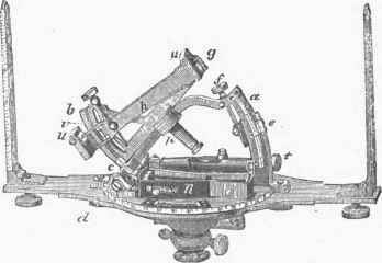
Solar Compass.
Burt, says that in running the line between Iowa and Minnesota, he could not distinguish upon the map of the largest scale the line it fixed from that determined by the most careful astronomical observations.
Continue to:
My Books